.png)
For the best experience, click here to open the map in a separate tab and interact as you read. The legend button is in the top button in the left corner.
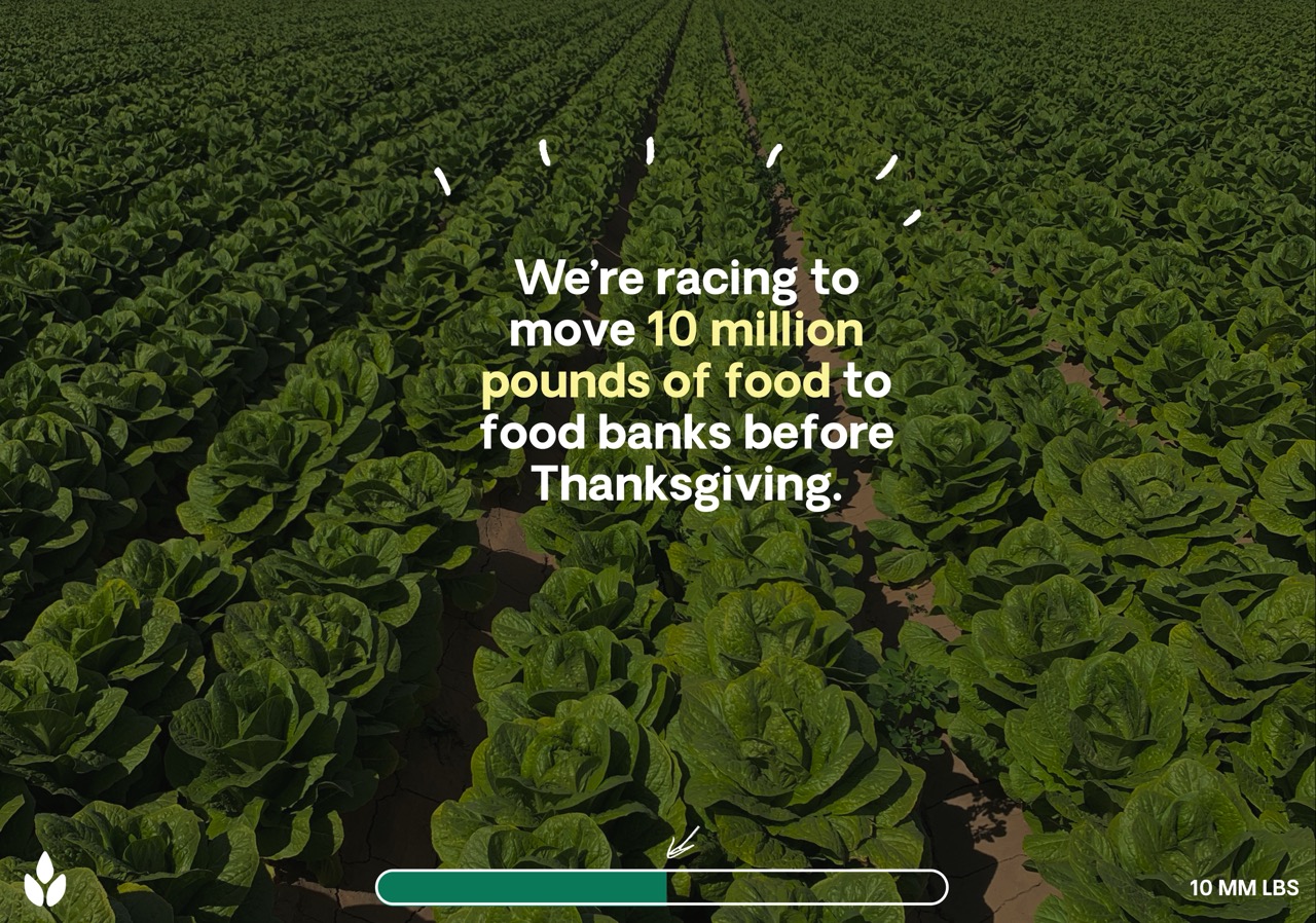
Hurricane Helene: A Glimpse of What’s Coming
In September 2024, Hurricane Helene barreled through towns across the East Coast, traveling far further inland than expected. In eastern Tennessee and North Carolina, rolling mountains funneled heavy rains into sudden surges of water, causing flash floods that destroyed entire towns. As ocean temperatures rise, each hurricane season brings the potential for greater and more catastrophic storms.
When The Farmlink Project responded with fresh food, water, and critical supplies, our recipient partners faced increased obstacles in getting the supplies to affected areas. The highways and major roads that the semi-trucks carrying the rescued food needed to safely reach communities had been torn apart by floods. Partners adapted to reach isolated towns, some even carrying food on mules. In the wake of this climate change–exacerbated disaster, The Farmlink Project provided near-term relief by transforming surplus into urgently needed aid. For communities newly vulnerable to hurricanes, this food recovery work revealed something deeper.
Climate Change Drives Food Insecurity
As The Farmlink Project connected affected communities with fresh food and clean water, our partners confronted a new landscape shaped by natural disaster. The floods destroyed communities’ homes and roads. Their loss significantly weakened the infrastructure needed to respond to the resulting food insecurity and further exacerbated existing barriers to food access.
Our best shot at ending hunger in our lifetimes comes from understanding that climate change does not simply intensify the challenges of hunger; it directly drives food insecurity and often blocks efforts to relieve it. Stronger storms can trigger flash floods that wipe out harvests and isolate communities, while longer droughts can starve crops of water or force farmers to rely heavily on costly irrigation. The result is the same: food becomes harder for farmers to produce and for families to access. Farmers in West Virginia already struggle with drought that makes it difficult to plan for the next season, while recipient partners need cold storage, open space, and reliable roads to keep food moving. Every part of the food system depends on a stable climate.
A Map for Action
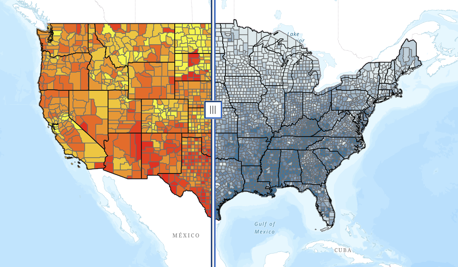
That is why Farmlink, in collaboration with From Soil to Soul, has built the Climate Risk & Food Insecurity Map. This interactive tool allows you to view, county by county, where climate vulnerability and food insecurity overlap. The same counties facing droughts, floods, and extreme weather are often also facing serious food insecurity and income inequality.
Each layer displays either food insecurity rates or climate vulnerability. To the left, the closer a county is to red, the higher its food insecurity is. To the right, the closer a county is to dark blue, the more vulnerable it is to climate change—whether that’s from weakened infrastructure, systemic poverty, or physical exposure to weather events. Sliding the tool in the middle enables viewers to compare food insecurity and climate vulnerability in each county, telling the story that grounds Farmlink’s work and vision for change.
We built this county-by-county map to make these realities more visible. While for many, the effects of climate change are beginning to move closer to home, for countless others, the effects are at their doorsteps and have been for some time. This map is a window into that lived experience, and the systemic issues that shape it.
Food Recovery Is Climate Action
Farmlink’s work has always been about more than moving food. With each truckload we recover, we expand access to nutritious food and prevent carbon emissions that warm the planet and increase climate vulnerability and risk. Food recovery is one of the most immediate and scalable climate- and hunger-fighting solutions we have. It is an act of care for the people who need to eat today and an investment in the stable climate all communities and food systems depend on tomorrow. It is an act of care for the planet itself, and a step toward ending hunger in our lifetimes.
At Farmlink, we believe ending food insecurity in our lifetimes means building a food system resilient to climate change, rooted in reciprocated abundance, and committed to the well-being of both communities and the planet.
Dont forget to check out our map, click here to view.
This map was created in partnership with From Soil to Soul.
From Soil to Soul is a powerful documentary series that explores the journey from food injustice to food sovereignty through the voices of BIPOC farmers, activists, and regenerative practitioners. More than just a film, it’s a movement to reclaim our relationship with the land and our right to grow, share, and honor our food. Rooted in justice, sustainability, and cultural wisdom, the series envisions a world where every community has the power to nourish itself. Follow their journey here.
Map Data Sources:
Food Insecurity (2023) | Feeding America Map the Meal Gap (2023)
Climate Vulnerability Index | Environmental Defense Fund U.S. Climate Vulnerability Index
< Back
For the best experience, click here to open the map in a separate tab and interact as you read. The legend button is in the top button in the left corner.
Hurricane Helene: A Glimpse of What’s Coming
In September 2024, Hurricane Helene barreled through towns across the East Coast, traveling far further inland than expected. In eastern Tennessee and North Carolina, rolling mountains funneled heavy rains into sudden surges of water, causing flash floods that destroyed entire towns. As ocean temperatures rise, each hurricane season brings the potential for greater and more catastrophic storms.
When The Farmlink Project responded with fresh food, water, and critical supplies, our recipient partners faced increased obstacles in getting the supplies to affected areas. The highways and major roads that the semi-trucks carrying the rescued food needed to safely reach communities had been torn apart by floods. Partners adapted to reach isolated towns, some even carrying food on mules. In the wake of this climate change–exacerbated disaster, The Farmlink Project provided near-term relief by transforming surplus into urgently needed aid. For communities newly vulnerable to hurricanes, this food recovery work revealed something deeper.
Climate Change Drives Food Insecurity
As The Farmlink Project connected affected communities with fresh food and clean water, our partners confronted a new landscape shaped by natural disaster. The floods destroyed communities’ homes and roads. Their loss significantly weakened the infrastructure needed to respond to the resulting food insecurity and further exacerbated existing barriers to food access.
Our best shot at ending hunger in our lifetimes comes from understanding that climate change does not simply intensify the challenges of hunger; it directly drives food insecurity and often blocks efforts to relieve it. Stronger storms can trigger flash floods that wipe out harvests and isolate communities, while longer droughts can starve crops of water or force farmers to rely heavily on costly irrigation. The result is the same: food becomes harder for farmers to produce and for families to access. Farmers in West Virginia already struggle with drought that makes it difficult to plan for the next season, while recipient partners need cold storage, open space, and reliable roads to keep food moving. Every part of the food system depends on a stable climate.
A Map for Action
That is why Farmlink, in collaboration with From Soil to Soul, has built the Climate Risk & Food Insecurity Map. This interactive tool allows you to view, county by county, where climate vulnerability and food insecurity overlap. The same counties facing droughts, floods, and extreme weather are often also facing serious food insecurity and income inequality.
Each layer displays either food insecurity rates or climate vulnerability. To the left, the closer a county is to red, the higher its food insecurity is. To the right, the closer a county is to dark blue, the more vulnerable it is to climate change—whether that’s from weakened infrastructure, systemic poverty, or physical exposure to weather events. Sliding the tool in the middle enables viewers to compare food insecurity and climate vulnerability in each county, telling the story that grounds Farmlink’s work and vision for change.
We built this county-by-county map to make these realities more visible. While for many, the effects of climate change are beginning to move closer to home, for countless others, the effects are at their doorsteps and have been for some time. This map is a window into that lived experience, and the systemic issues that shape it.
Food Recovery Is Climate Action
Farmlink’s work has always been about more than moving food. With each truckload we recover, we expand access to nutritious food and prevent carbon emissions that warm the planet and increase climate vulnerability and risk. Food recovery is one of the most immediate and scalable climate- and hunger-fighting solutions we have. It is an act of care for the people who need to eat today and an investment in the stable climate all communities and food systems depend on tomorrow. It is an act of care for the planet itself, and a step toward ending hunger in our lifetimes.
At Farmlink, we believe ending food insecurity in our lifetimes means building a food system resilient to climate change, rooted in reciprocated abundance, and committed to the well-being of both communities and the planet.
Dont forget to check out our map, click here to view.
This map was created in partnership with From Soil to Soul.
From Soil to Soul is a powerful documentary series that explores the journey from food injustice to food sovereignty through the voices of BIPOC farmers, activists, and regenerative practitioners. More than just a film, it’s a movement to reclaim our relationship with the land and our right to grow, share, and honor our food. Rooted in justice, sustainability, and cultural wisdom, the series envisions a world where every community has the power to nourish itself. Follow their journey here.
Map Data Sources:
Food Insecurity (2023) | Feeding America Map the Meal Gap (2023)
Climate Vulnerability Index | Environmental Defense Fund U.S. Climate Vulnerability Index
Connecting Food Security and Climate Risk: A New Map for Action
The United States
For the best experience, click here to open the map in a separate tab and interact as you read. The legend button is in the top button in the left corner.
Hurricane Helene: A Glimpse of What’s Coming
In September 2024, Hurricane Helene barreled through towns across the East Coast, traveling far further inland than expected. In eastern Tennessee and North Carolina, rolling mountains funneled heavy rains into sudden surges of water, causing flash floods that destroyed entire towns. As ocean temperatures rise, each hurricane season brings the potential for greater and more catastrophic storms.
When The Farmlink Project responded with fresh food, water, and critical supplies, our recipient partners faced increased obstacles in getting the supplies to affected areas. The highways and major roads that the semi-trucks carrying the rescued food needed to safely reach communities had been torn apart by floods. Partners adapted to reach isolated towns, some even carrying food on mules. In the wake of this climate change–exacerbated disaster, The Farmlink Project provided near-term relief by transforming surplus into urgently needed aid. For communities newly vulnerable to hurricanes, this food recovery work revealed something deeper.
Climate Change Drives Food Insecurity
As The Farmlink Project connected affected communities with fresh food and clean water, our partners confronted a new landscape shaped by natural disaster. The floods destroyed communities’ homes and roads. Their loss significantly weakened the infrastructure needed to respond to the resulting food insecurity and further exacerbated existing barriers to food access.
Our best shot at ending hunger in our lifetimes comes from understanding that climate change does not simply intensify the challenges of hunger; it directly drives food insecurity and often blocks efforts to relieve it. Stronger storms can trigger flash floods that wipe out harvests and isolate communities, while longer droughts can starve crops of water or force farmers to rely heavily on costly irrigation. The result is the same: food becomes harder for farmers to produce and for families to access. Farmers in West Virginia already struggle with drought that makes it difficult to plan for the next season, while recipient partners need cold storage, open space, and reliable roads to keep food moving. Every part of the food system depends on a stable climate.
A Map for Action
That is why Farmlink, in collaboration with From Soil to Soul, has built the Climate Risk & Food Insecurity Map. This interactive tool allows you to view, county by county, where climate vulnerability and food insecurity overlap. The same counties facing droughts, floods, and extreme weather are often also facing serious food insecurity and income inequality.
Each layer displays either food insecurity rates or climate vulnerability. To the left, the closer a county is to red, the higher its food insecurity is. To the right, the closer a county is to dark blue, the more vulnerable it is to climate change—whether that’s from weakened infrastructure, systemic poverty, or physical exposure to weather events. Sliding the tool in the middle enables viewers to compare food insecurity and climate vulnerability in each county, telling the story that grounds Farmlink’s work and vision for change.
We built this county-by-county map to make these realities more visible. While for many, the effects of climate change are beginning to move closer to home, for countless others, the effects are at their doorsteps and have been for some time. This map is a window into that lived experience, and the systemic issues that shape it.
Food Recovery Is Climate Action
Farmlink’s work has always been about more than moving food. With each truckload we recover, we expand access to nutritious food and prevent carbon emissions that warm the planet and increase climate vulnerability and risk. Food recovery is one of the most immediate and scalable climate- and hunger-fighting solutions we have. It is an act of care for the people who need to eat today and an investment in the stable climate all communities and food systems depend on tomorrow. It is an act of care for the planet itself, and a step toward ending hunger in our lifetimes.
At Farmlink, we believe ending food insecurity in our lifetimes means building a food system resilient to climate change, rooted in reciprocated abundance, and committed to the well-being of both communities and the planet.
Dont forget to check out our map, click here to view.
This map was created in partnership with From Soil to Soul.
From Soil to Soul is a powerful documentary series that explores the journey from food injustice to food sovereignty through the voices of BIPOC farmers, activists, and regenerative practitioners. More than just a film, it’s a movement to reclaim our relationship with the land and our right to grow, share, and honor our food. Rooted in justice, sustainability, and cultural wisdom, the series envisions a world where every community has the power to nourish itself. Follow their journey here.
Map Data Sources:
Food Insecurity (2023) | Feeding America Map the Meal Gap (2023)
Climate Vulnerability Index | Environmental Defense Fund U.S. Climate Vulnerability Index
.svg)
.svg)
.svg)